14 February 2011

Welcome to Pine Mountain Club

Southern California has a large population which is mostly clustered along the coast. Huge expanses of undeveloped open space exist inland, populated only by those resillent and self-reliant enough to handle the isolation. Maricopa and Pine Mountain Club are two towns which stand alone as distant outposts of the southern California conurbation. I had to go exploring and see what was out there, and I found a lot of empty, calming beauty.

Route Outline: 545 KM total

I started by wandering down hwy 101 from Santa Barbara to HWY 150, which I took over Casitas Pass into the small town of Ojai, CA. Ojai is a quaint community in the mountains above Ventura, and has a great charm to it.

Downtown Ojai on a stormy day

I follow highway 33 north out of Ojai up and over a steep st of mountains. It was a crazy, curvy drive!

Pine Mountain Pass above Ojai, CA on HWY 33
North is to the left

Winding our way up HWY 33

Pine Mountain Summit looking south


After crossing Pine Mountain Pass, I drove across the flat Cuyama Valley, which has some agriculture but is largely isolated. It was breathtaking was scored with dry river beads and beat-up old roads. I followed one such road off the east side of HWY 33, and the scenery was breathtaking. It was a dirt loggin track, and my car was only able to go a little ways before the terrain got too rough.

HWY 33 - Cuyama Valley

Logging road we took


Scenery off logging wood - high arid plains

we climbed to the top of this!

My copilot Ian (left) and I


Distant destinations on the edge of the central valley

We followed hwy 33 North and East and we tempted to turn off on the twisting Cerro Noroeste Rd., which turned into Forest HWY 95 and started to climb up the edge of a sheer valley. The temperature started to drop, and the road got steeper and steeper with rocks and ice everywhere!

Forest HWY 95 led to the tiny community of Pine Mountain Club. This town is tucked away at the foot of a huge mountain, and is located at about 1500 m elevation. It was COLD and there was snow on the ground! Spectacular! PMC is a small, privately owned community. The house were very cute, and the streets were steep and surrounded with evergreen trees.

Forest HWY 95/ Cerro Noroeste Rd to Pine Mountain Club. Looking South

Forest HWY 95 into Pine Mountain Club

Closeup of town nestled on north-facing slope
1500 M elevation
Looking south
The Range above Pine Mountain Club. the peaks reach close to 2500 m above sea level.
Looking South
After leaving Pine Mountain Club, we headed back down the way we came, and turned back onto HWY 33 continuing East toward Maricopa. A steep, sudden grade took us down into the valley, and Maricopa slowly revealed itself on the horizon. It was a small, sleepy town on the edge of the immense central valley of California, and the buildings were sparse and drab. The area has had a weak economy which has veen closely tied to the booms and busts of oil and gas drilling in the area, and now does not look like such a good time in Maricopa. Still, it was a beautiful piece of California which is definitely off the beaten path!

Treacherous grade down into the central valley

Elevation and Speed Profile


Thanks for the read! More info about this trip to come soon!


11 February 2011

Visit Museo del Prado in Spain!

Google recently launched a virtual tour of a variety of museums around the globe. You can view the floorplan of the museum and even look at high quality reproductions of the works contained within.


One of the Museums not viewable via Google Art Project


On such museum, The Prado Museum in Madrid, Spain houses a world class collection 12th-19th century European art. Founded in 1918, the museum has over 7,000 pieces, although due to space limitations only about 1300 are on display to the public.


Real Life Image of Museo Prado


Arial of Museum and adjacent park


Google Art depictions of the Palace of Versailles


View of a gallery in The Museum of Modern Art in New York


Van Gogh's Museum in Netherlands 


Close up of Van Goug's "Bedroom" via Google's Art Project

Looking North up Paseo del Prado, with Museum visible on right


The quality of the images are truly breathtaking. When an image is selected for viewing in Google Earth, if flies the viewer to where in the building the work is located, giving one a sense of the museum's layout. I would highly recommended checking out this museum yourself in Google Earth. So far, its kind of buggy and takes powerful hardware to render properly, but it is worth the patience!

Close up section of 'Self Portrait' by Albrecht Dürer, as seen in Google Earth tour of Museo del Prado 


Looking south down Paseo del Prado
Check out the Google Art Project website here to see more museums and works. You can move around the museum and view the works in high resolution! You can also view the museum's exterior detail in Google Earth. I imagine that Art Project will eventually merge completely with Earth. Google has already rendered the outsides of most buildings, so it makes sense that they'll work on the insides now!


Check out this video from Google Spain showing how high res imagery of these entire museums were collected and modeled into a 3D model 


09 February 2011

3D flyover of Washington DC

I woke up feeling patriotic this morning. There is no better way to honor one's country than by checking out the capital. I wsan't feeling up to flying there, so I'd figured Google Earth could take us. Lets see what we find!!

The U.S. Capital building 


A view of the National Mall from over the Potomac 


Jefferson Memorial


Lincoln Memorial


Reflecting pool - Home of Martin Luther King's Famous "I have a dream" speech

Pentagon - Home of the U.S. armed forces

Smithsonian Institute
Washington D.C. has some gorgeous buildings, and the mall area itself is a wonderful urban space. Its obviously worth a visit if you've never been. Special thanks to the Google Earth community for all this wonderful 3D building imagery that has been created! A lot of America's cities are starting to look very realistic.

Want to see the video flyover? Download this KML file and open it in Google earth. It will allow you to play it like a video file. Definitely worth checking out! Download here

07 February 2011

Bicycling on the South Coast


Santa Barbara County is home to some of the most beautiful biking and hiking in the state! The diverse geography includes mountains, valleys, coastal plains and rolling hills. Breathtaking views are available from every peak, and the weather is always perfect.

Recently, I went biking in the San Rafael Wildness Preserve about 35 miles north of Santa Barbara. The San Rafael mountins run along the northern edge of the Santa Ynez valley, and make a stark contrast to the sweeping valley floor. The valley is home to a number of delightful towns including Solvang, Buellton and Santa Ynez. These communities are perfect to get away from life in busy LA and relax for an afternoon or a week!


"Start" indicates where our ride started. The red line is showing our ride's relative location to Santa Barbara (about 35 miles)


Overview of the ride path... very curvy!


Looking at our ride path from Solvang, on the floor of the valley.


Elevation is in Red, Speed is in blue
Download the Google Earth KML file here

04 February 2011

Storm Damage Ahead: A Trip Through "Rural" Santa Barbara

Refugio Road is narrow, curvy road which offers tremendous views of the coast and valley. Starting at the coast, the road winds its way up Refugio Canyon until it connects with Camino Cielo near the crest. There are some houses out in the canyon but the road is mostly isolated. Residents must be self-sufficient as the road fjords several streams which quickly swell with any rain! Storm damage is frequent, and help is slow in coming due to the remote location. If you try this drive, take it very slow! Watch for gravel, pot holes, and oncoming traffic! There are numerous one lane sections where passing is impossible. Oh, and enjoy the view! It's breathtaking from the top!


Overview of Route


Looking down the coast from Gaviota

View from 10 miles out to sea!

Refugio Road and Camino Cielo Road

Steepest grade on Refugio... could have used more switchbacks!

Panoramic House!

Looking down at both the start and end of the route
Opps! Almost forgot the elevation/profile graph!

Red is elevation, and Blue is speed!

Download the KML file

02 February 2011

New Blog Section: Gear I use

Today I am starting the 'gear I use' page. Here, I will detail what gadgets I use to make geography more fun! I focus on the overall user experience of the device, and generally will only recommended products that I feel very satisfied with. The proper tools will help you get a lot more out of your spatiality experience, and may even prevent injury via good ergonomics!

http://bytemaps.blogspot.com/p/what-i-use.html

Check out what I use, and let me know what you think! This list will be updated and 'fleshed out' regularly.

Cheers!

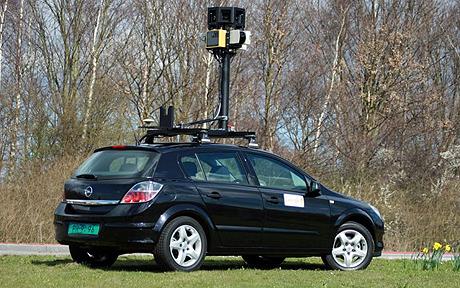
A Google Street View Car - the ultimate GPS device!

01 February 2011

A Look Back: Urban Planning in America

The United States has a long history of Urban Planning, and an equally lengthy history of planning controversies. Americans generally approve of small scale local community planning, but residents are wary of any overreaching or burdensome planning. Americans like their communities to be clean, liveable and attractive, but they are generally hesitant to take steps to achieve such a result.

Never the less, the United States has some prime examples of revolutionary urban master plans. The 1950s saw an explosion of this low-density, suburban tract housing being built in master-planned communities. Americans moved into the suburbs in droves, aided by the automobile and ever-expanding network or highways.

Examples of Master-Planned Communities

Radburn, New Jersey and Levittown, New York are models of early suburban sprawl. As master planned communities, both these towns offered the spacious lots, good schools, and affordable prices which Americans desired. They also, however, ingrained in the American psyche a reliance on the private car which as we're now seeing has unfortunate consequences. 

Levittown, New York

For example, Radburn introduced the residential 'super block.' This land use layout called for a grid of large roads spaced 1 KM or more apart. Each 'square' would contain lots of houses and parks, and would be accessed via extensive bike paths and some roads (with lots of cul-de-sacs). This effectively created a mini-suburb within each square of the road grid.

A residential 'superblock' with large perimeter roads, and bicycle paths and smaller roads within. 
Cities such as Radburn and Levitttown set the stage for the surburbinization of America. Some other more efficient, ecological planning ideals did not quite catch on


Rise and Fall of the Garden City
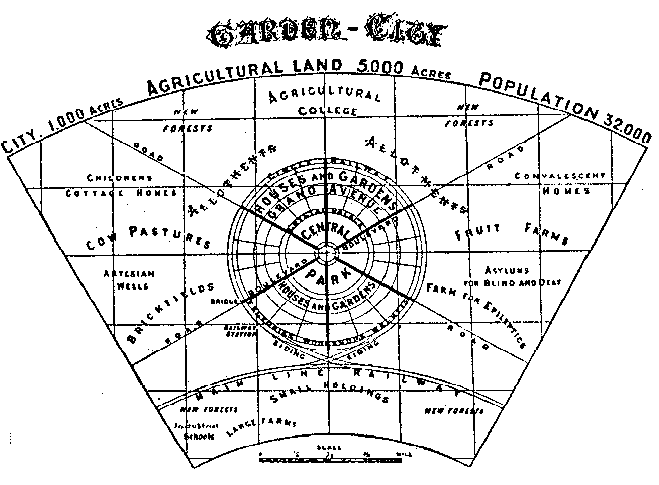
In the early 1900's, Ebenezer Howard designed a master layout known as the garden city. This regional planning strategy called for a series of dense, radial cities clustered around a major urban area, with efficient interconnections via municipal rail. This plan also emphasized the importance of green space in urban settings, and set aside large tracts of land in the city center for public use as open space.

The layout of Howard's "Garden City", with the main community in the center, and rail lines intersecting it diagonally to other communities. Unfortunately, modern planners often replaced rail lines with freeways when implementing this technique.

Garden Cities had some key advantages over "Levittown" style developments, They encourage a healthy lifestyle as they are designed for foot and bicycle traffic over automobile traffic. Communities are designed to be walkable, and house are set so porches face one another, encourage interaction among neighbors. Essentially, a city inspired by the 'garden city' design is a very nice, safe, healthy place to live.

One segment of a 'garden city.' Depicted are the wide avenues, parks, and hierarchical
arrangement of housing and commercial arrangement. 


The Bottom Line
America is a nation of large lots, single family homes and suburbs connected via freeway. Most of our urban planning takes after the 'Levittown' approach as opposed to building luxurious, aesthetically pleasing 'garden city' communities. 

Google Earth imagry of Levittown, NY Urban Sprawl

Concise, organized layout of Letchworth, England, which was based on the "garden city" design.