19 September 2011

Always Take The Road Less Traveled Pt 1

As summer draws to a close, it is time to pack the bags, load up the compact sedans, and head back to college! I always like to start off the year with an adventure, so I pulled out my map and picked a nice, long, curvy route from the San Francisco Bay Area back to Santa Barbara. 

I decided to take California Hwy 33 for as long as possible during my drive. Hwy 33 runs north-south down California's Central Valley parallel to I-5, and provides a scenic look at a number of small oil towns, and the Petroleum fields which surround them.

To get to Hwy 33 however, I'd have to take Interstate 580 out of the bay area to catch Interstate 5 in California's Central valley. From the 5, as it's locally known, I would be able to catch Hwy 33 South through valleys and mountains, eventually ending up at the Central Coast! Over the next couple days, I will be profiling each highway segment I covered on this trip. 

Route Overview - 367 miles/590 kM


I started my trip from a friend's house in Berkeley right near the Interstate! I got on I-580 East and followed it through the Oakland Hills and Castro Valley out of the Bay Area!
I-580 heading out of Berkeley, CA towards Tracy
Heading through the Altamont Pass


Approaching the Windmills!
Driving through the Altamont Pass


In the eastern reaches of the Bay Area, Interstate 580 goes over Altamont Pass in California's Diablo Mountain Range and the towering wind turbines perched high above the freeway on the ridges. Altamont Pass Wind Farm is one of the oldest in the United States, and produces an average of 125 Megawatts


Heading south in California's central valley where the I-580 splits with I-205
After the Altamont Pass, it gets flat and straight for hundreds of miles. The surrounding land is mostly agricultural, with some industrial areas. Few notable landmarks are present aside for the occasional truck stop.


I-580, 205, and 5 for a triangle in the central valley. 

Passing Wind Turbines at Safeway's HUGE distribution plant near Pleasanton
Interstate 5 is California's major North-South artery connecting Sacramento and the Bay Area to Southern California. Most people driving this route are on a long distance trip!
I-580 near I-5. It will look like this for a while now!

Its rare to see speed limits above 65 MPH(104kM/h) in California


Now I am in California's Central Valley making my way south! The next post will take us down I-5 to Hwy 33. Cheers!

04 June 2011

Potato Bay - Santa Cruz Island

The banks of Potato Bay rise steeply out of the Pacific on the northern side of Santa Cruz island. This breathtaking inlet instills the awe of nature in ones being when view from the bluffs above, and to a weary ship at sea it beckons protection from the wind and choppy ocean water


Potato Harbor - Photo Credit: Gneiss_kitty 

To get to the cove we left camp and climbed the eastern side of scorpion canyon (opposite side as yesterdays hike) and walked along the bluffs overlooking the ocean with stunning views of Anacapa island. 


Ascent out of Scorpion Canyon shown in red


Scorpion Canyon during our ascent


The trail


Anacapa Island peering at us through the fog


Entire Route


View from the bluffs


Not the softest beach

The bluffs plunged directly into the ocean mostly, but occasional a rocky beach could be spotted. The terrain is primarily dry grassland with some small shrubbery. The island originally had nearly impenetrable vegetation, but the sheep brought in by ranchers profoundly altered the island's vegetation.


A look inland


Sheer bluffs along potato bay (note our path in upper left)


Potato Bay

The bay reminded me of a tropic island. The water was almost clear blue, and the air was fresh and warm. This picture below demonstrates how big the island is... notice the other side of Santa Cruz island in the background.


(That's still Santa Cruz Island in the distant background)


Unforgiving banks, harsh vegetation


Life is sweet on the Jenny May


On the walk back


Fields of yellow


Speed Elevation Profile

Download the KML file to explore further in Google Earth

27 May 2011

Hike to Smuggler's Cove - Santa Cruz Island

Right when I arrived on Santa Cruz island, we set up camp and than left to go on our first hike. We headed up the canyon towards Devils Peak, which is the island's highest point at an elevation of 2450 feet. At the top of ridge, we headed across a flat bluff and wound our way down into smugglers cove on the island's southeastern tip. 


Our steep ascent out of camp in Scorpion canyon


Hiking up the Canyon


Across the ridge and down into smugglers cove


Looking across the ridge near smugglers cove


Path into Smuggler's cove through a
picturesque grove of Olive trees


Smuggler's Cove


Another view of the cove


Inland portion of smuggler's cove


Farmhouse in Smugglers Cove

During this hike Santa Cruz island unique fauna put on a great show. The island is home to the Island Scrub Jay, which is much bigger than its mainline relative. Each island is also home to a unique species of fox. These foxes are extremely cute, but they tend to be aggressive and will come right up to people while attempting to steal food. They were all over our camp and would sneak up whenever we had our backs turned!


An island fox raiding out picnic!


Route back down to camp


View coming back down to Scorpion Cove


Complete Route


So we took a different route to and from Scorpion cove


Elevation and speed profile, with a break in the middle as we
ate in Smuggler's cove

Download the KML file here to explore this hike in Google Earth!


26 May 2011

Boat Ride to Santa Cruz Island

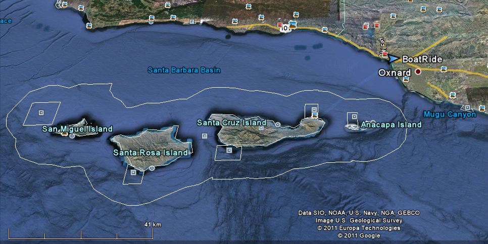
I recently got back from a weekend camping trip on Santa Cruz Island, which is part of the magnificent Channel Islands off of Central California. I went with the UCSB adventure program, which organizes outdoor wilderness trips in and around California and across the country. This program is a great way to get out and see nature while networking with people in the Santa Barbara area.

We met at Ventura Harbor at 7 am to catch a ferry out to the island. It was a 25 mile ride across the choppy channel waters, and took a little over 1 hour. Along the way we saw lots of birds and dolphins. At one point, a school of around 100 dolphins were surround the boat, jumping out of the water as we went. It was quite a miraculous sight to see all these creatures.


Channel Islands Nation Park (white perimeter line)

leaving Ventura harbor, with a quick detour to see some Dolphins


The Santa Barbara Channel is a unusual feature in California geography. The 30 mile wide channel separates the Northern Channel Islands from mainland California. As we left Ventura harbor, the first half of the channel was approximately 90 feet deep. About ten miles into the channel, however, the ocean floor drops off and water depth increases to around 1000 feet in about 1/4 mile! Lots of oil drilling takes place along this drop off, and it attracts ample sea life as well. In fact, right around this area was where we encountered our dolphin school!

Santa Cruz Island


Our Landing at Scorpion Cove


Scorpion Cove landing - the boat just noses up to the pier and one must
hop off quickly!


Just made camp - Nice view to wake up to in the morning!


The island has a huge fox population, and they are super cute and
not afraid of people!


The whole boat ride to the island

Download the KML file to play with in Google Earth!

View more photos of the trip!

23 May 2011

Asleep at the keyboard

Hello all! Sorry for the lack of posts. It has been a crazy quarter....

I just returned from a camping trip in the Channel Islands. I will be adding maps and pics to the blog over the next couple days, so be sure to check them out!

09 May 2011

Repost: Mental Maps w/ better scan quality

The following is a repost which includes new, higher resolution images.


Environmental Cognition and Perception: What does it mean? According to UCSB's Dr. Dan Montello, perception and cognition of one's environment is the process of finding one's way, identifying dangers and resources, and in a more general sense how one's environment is understood. A great demonstration of this concept is the Mental Sketch Map, or a hand drawn map from memory of an area that one is quite familiar with.

UCSB official campus map
 I recently had to collect mental sketch maps from several peers for my Environmental Perception class here at UCSB. The idea was to see how UCSB students recalled campus and to see how campus was laid out in each other minds. One may be able to navigate around campus quite efficiently, but recalling all that data on a piece of paper at one time is much more difficult.

My six participants received these instructions and produced the following six maps: (please excuse the poor scan quality!)


20 year female campus resident


20 year old male Isla Vista resident


19 year old female campus resident


21 Male living in Isla Vista


21 year old male living in Isla Vista


21 year old male living in Isla Vista


Results:
  • Most people are unfamiliar with buildings on the north side of campus (mostly administrative buildings)
  • Living in Isla Vista gives one much more limited view of campus which largely excludes the dorm areas, etc
  • One's mode of transportation greatly affected perception: those who bike always put bike paths down first, and those who walk start with foot paths! 
  • No one could correctly locate Campbell hall, although it is the largest lecture hall on campus which EVERY UCSB has had class in at least once.... 
Now: take another look at UCSB's offical campus map. The maps I collected from my participants varied greatly in layout, accuracy, and usefulness, but its extremely interesting to see how people perceive their surroundings.

Again, Official UCSB campus map