12 January 2012

Piedra Blanca

Piedra Blanca National Recreation Trail goes for two miles across a beautiful high mountain regions of Southern California. This trail is located up in the hills above Ojai, CA. The trail head is about 3 hours away from Los Angeles by car and provides a welcomed retreat to an afternoon of peace and quiet without being too far from home.

Rock Formations at Piedra Blanca

The rock formations are nestled in a valley in the shadow of the great Pine Mountain Ridge. I found it fairly easy to hike up these formations, and the view from the top was outstanding!

The hike itself was quite easy; the trail is relatively flat until the very end. There are three river crossings, but they are early on in the hike and quite manageable.


At times the trail would be hard to follow if not for the Nation Park Service's Signs!
Here is an overview of our hike, showing the Parking lot and trail head (A), Stream Crossings (B) and Top of the Second Tallest Rock in the Piedra Formation. Rose Valley Road is nicely paved inbetween the trail head and the highway, and the trail head offers plenty of parking, restrooms, and picnic tables!


My hike: Started and Ended at A!

Once I crossed the triple river crossing, the landscape opened up into a wide plane which showed extensive scarring from previous glaciation. The result were rocks and hills with geometric patterns carved neatly into them. The picture below shows the view from the river towards the rock formations, with Pine Mountain Ridge looming in the background. We climbed to the 'C' at the top of the peak.
Hiking up the glacier-scarred plane towards the rock formations.


StateParks.com describes Piedra Blanca Trail as follows:
A 17.7 mile trail in the Sespe Wilderness through impressive white rocks to a number of wilderness campsites. Designated a National Recreation Trail in the Los Padres Condor Range and River Protection Act. Named for Gene Marshall, a leading advocate of wilderness designation for the Sespe who played a key role in the development of the Los Padres Condor Range and River Protection Act. In the Ojai Ranger District the Gene Marshall-Piedra Blanca National Recreation Trail offers Wilderness access along an eight and seven tenth mile trail. First half easy, then very steep climb. Drive to Lion Campground at the end of Rose Valley Road. Cross the wide stream bed and take the trail to the left. After about half a mile turn right at the junction. This will bring you through the impressive white rocks and to Piedra Blanca Camp after 2.7 miles. Twin Fork Camp is a half mile further and has water most of the year. Trail to Pine Mountain Lodge Camp is another 3 miles, very steep in places, but well worth the visit. This camp is nestled in the conifers and has water close by. From the junction at Pine Mountain Lodge, the Piedra Blanca Trail continues northwest to Haddock and Reyes Creek Camps. The trail which goes east takes you to Fishbowls or Cedar Creek Camps on the Mt. Pinos Ranger District.
Use the viewer below to look at my path - you can zoom, tilt, and pan to get a look from any angle you wish! Also, adjust the slider in the top left corner to see where I was exactly at any time!


Creative Commons License
Piedra Hike Blog Post and related content by Thomas Vieira is licensed under a Creative Commons Attribution-NonCommercial-ShareAlike 3.0 Unported License.

27 December 2011

Geo-tag your photos with PhotoGPS

Need a better way to organize your photos? If you have a DSLR camera the PhotoGPS by Jobo is a great way to geotag every photo you take quickly and easily. The PhotoGPS dongle attaches to the camera's hot shoe, and is automatically activated every time a picture is taken. 

The PhotoGPS geo-tagging attachment


Once the photos are loaded on a computer, included software quickly and easily matches up each photo with its recorded location. This software allows photos to be displayed on a map, and even use reverse geo-coding to add a variety of other information about the location in which the photo was taken. 

In short, PhotoGPS is a quick, easy way to geo-tag all your photos with detailed location metadata.


A DSLR with PhotoGPS attached.


Read more about PhotoGPS at Absolutely GPS

21 December 2011

Increasing Evidence Suggests GPS Threatened by LightSquard's LTE Network

The American Surveyor presented an article today outlining mounting evidence which suggests LightSquared's LTE network interferes with GPS, with potentially disastrous consequences for commercial, military and civilian navigation. LightSquared is attemping to build a nationwide wholesale LTE data network to resell to carriers without a 4G network or who need to expand their coverage. If built, this network will use a combination of traditional LTE augmented by satellite-based technology [source], and LightSquared claims that users will enjoy coverage no matter where they are in the United States

LightSquared is pressing ahead with its roll-out plans despite objections from leading GPS receiver manufacturers as well as organizations which depend on GPS-based navigation. Jim Kirkland, Vice-President of navigation equipment manufacturer Trimble, stated that despite continued revisions of its network design, LightSquared is no where near proving that its technology is safe and will not interfere with GPS signals. 

Read what the experts have to say:

Jim Kirkland, Vice President and General Counsel of Trimble:
“Government tests conducted at the direction of the FCC and NTIA and reported on December 14thconfirmed yet again the depth and breadth of the serious GPS interference problems raised by LightSquared’s proposed plans, even after several revisions LightSquared claimed had ‘solved’ the interference problem. As far back as June, LightSquared has been downplaying GPS interference concerns, insisting that LightSquared and the GPS devices consumers use every day in their cars, trucks and boats, and used to make air travel safer to prevent loss of life in aviation accidents could coexist. The results are in – there are substantial risks to all of these everyday activities.


“This is on top of proven, undisputed interference to hundreds of thousands of high-precision GPS devices used in critical economic activities, including agriculture and construction, that account for three million jobs in the U.S. They are also used in critical government activities, including storm warning systems, mapping, and disaster monitoring and management. LightSquared insists that new equipment can reduce interference to high-precision GPS devices, but completely ignores the massive retrofit and replacement effort that would be required, which would cost billions of dollars across government and private industry and require years-long certification processes in industries like aviation.  


“As we stated last night in response to LightSquared’s most recent filing with the FCC, LightSquared continues to recycle the litany of inaccurate and self-serving claims it has made in its ongoing effort to deny its obligation to avoid harmful interference to millions of government and private GPS users. LightSquared continually minimizes or denies the GPS interference problem caused by its planned network, and its claims have been proven wrong again and again by overwhelming technical evidence. A year into this debate, many revisions to its plans notwithstanding, LightSquared is nowhere near satisfying the condition clearly laid down by the FCC last January that it must demonstrate that it will not interfere with GPS before it is allowed to implement its plans to use satellite spectrum.”   

[Please Note: The full Dec. 20 statement from Jim Kirkland is available later in this release.]


John Foley, Director, Aviation GNSS Technology, Garmin:
“The threat that LightSquared poses to Aviation GPS has been known since Garmin filed its initial test results with the FCC in January 2011. Numerous independent tests have validated these results multiple times in the ensuing months, and none of LightSquared’s proposals to date has addressed them. The recent joint statement from the Departments of Transportation and Defense noting the FAA’s finding of interference with GPS-based terrain awareness systems is just more confirmation.”

Bronson Hokuf, Principal Engineer, GPS Systems, Garmin: 
“Similarly, the threat that LightSquared poses for General Location/Navigation devices has been a matter of record for almost a year. Multiple tests since January 2011 have shown interference to a wide variety of GLN devices. LightSquared has tried to whitewash these results, even claiming last summer that 99.5 percent of GPS devices would be unaffected by its proposed operation. According to trade press reports, the latest testing at White Sands Missile Range demonstrated that a majority – 75 percent – of the GLN devices, in particular, showed harmful interference.”

Margaret Podlich, President of BoatUS:
“Boat owners take the responsibility for the safety of our family members and friends very seriously. To compromise one of their most important, reliable, and critical pieces of safety equipment, which is the essence of the Light Squared signal interference issue with GPS, is not only foolish, but irresponsible. No margin of safety should be reduced simply because a private corporation sees a new business opportunity.”

The following statement was issued Tuesday evening, December 20, by Jim Kirkland, Vice President and General Counsel of Trimble, a founding member of the Coalition to Save Our GPS:
“This latest filing simply recycles the litany of inaccurate and self-serving claims that LightSquared has made in its ongoing effort to deny its obligation to avoid harmful interference to millions of government and private GPS users. The filing entirely ignores the critical points relevant to its proposal to change the use of the mobile satellite band. First, LightSquared and its predecessors have always been prohibited from interfering with GPS.  Second, prior FCC decisions did not authorize the operation of a nationwide terrestrial broadband network in any way shape or form, LightSquared’s attempts to cherry pick irrelevant pieces of FCC decisions notwithstanding. In fact, the FCC repeatedly said that LightSquared’s predecessors would not be allowed to provide terrestrial-only service. Third, LightSquared never paid for full terrestrial rights to use its spectrum as required by law, and so cannot now claim superior rights to exploit its spectrum to the detriment of other authorized spectrum uses like GPS. Any ‘agreement’ by the commercial GPS industry to accommodate limited ancillary operations in LightSquared’s spectrum was made within this basic framework, and is not relevant to LightSquared’s current proposal. Given this basic framework, the suggestion that GPS manufacturers should have designed their equipment to accommodate a prohibited spectrum use is completely meritless.   

 “In its January 2011 order, the Commission made clear that LightSquared would not be permitted to commence operations until it had demonstrated that it would not interfere with GPS. LightSquared did not challenge this condition at the time, and has to live up to it. There is overwhelming technical evidence – the most recent of which was released by the Government just last week – that this condition has not been satisfied."

19 December 2011

Security: The Next Generation Location Based Service

Location-aware phones are ushering in a new generation of value added apps and services. Location Based Services (LBS) allow users to share their location with friends and loved ones, find out about nearby shopping specials, or even leave virtual 'post-it notes' to remind you of something when you arrive at work or home.

A  recent episode of Tech News Today highlighted how banks can use LOC-Aid's (pronounced loke-aid) services for fraud prevention. Click here to watch the segment of Tech News Today Episode 390 where host Tom Merritt explains how LOC-Aid can turn your phone into a tool to combat financial fraud.


LOC-Aid is the leading Location as a Service (LaaS) provider in the United States and Canada, with the ability to locate any smartphone or feature phone using only a 10 digit phone number. Don't worry - phones can only be located once the use has explicitly opted-in, and users may opt-out at any time. Locate your own phone using LOC-Aid's free demo.

Banks and financial institutions are increasing allowing customers use their mobile phone's location for added banking security. For example, a bank can locate the phone of a customer attempting to make a withdrawal to verify that the phone (and hence the customer) is near the ATM. If the phone is not near the ATM, the bank can take further action to verify the customer's identity.

Full Disclosure: I have consulted for LOC-Aid in the past.

28 September 2011

Pt 3

Here is the 3rd and final entry of A Road Less Traveled, my blog series detailing my summer roadtrip along California's scenic remote HWY 33. If you have not already, now would be a great time to read the first and second posts!

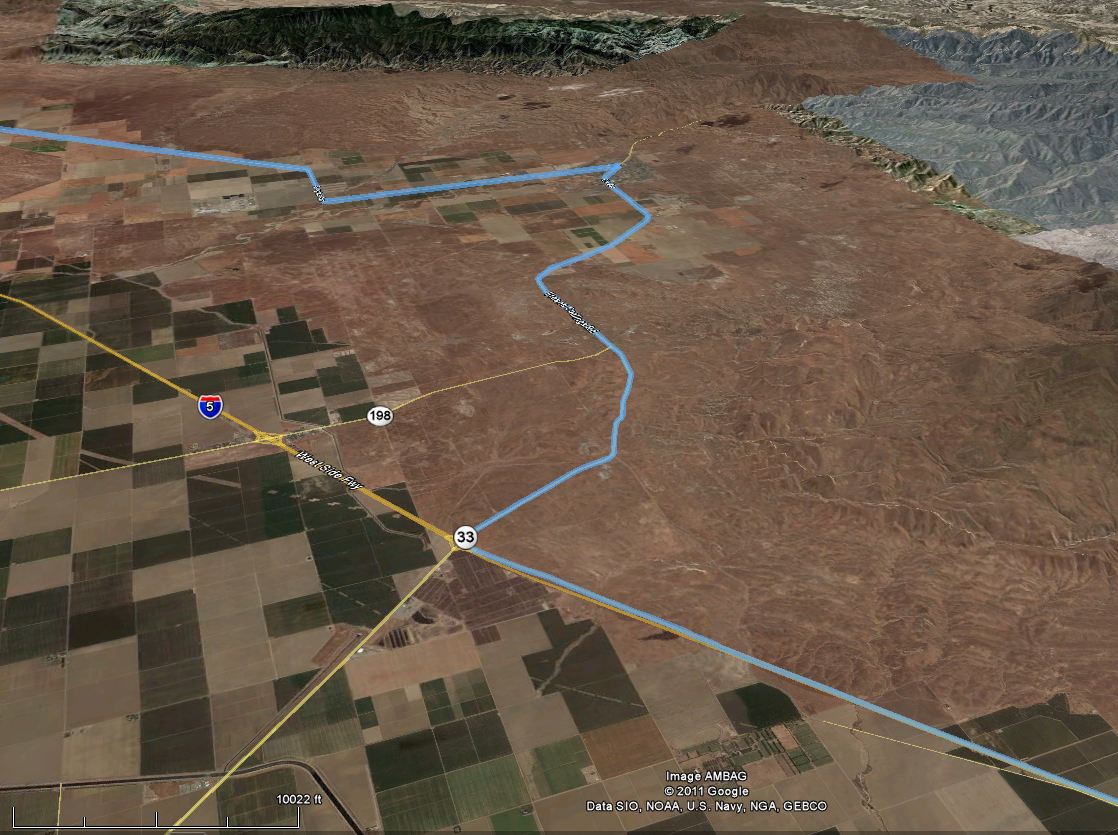
Here is a refresh of my complete Berkeley-Santa Barbara route:
Route Overview - 367 miles/590 kM


Hwy 33 through Coalinga
I exited Interstate 5 and headed south on California Highway 33. This area is quite desolate and has a lonely feel, and the sun was beaming down furiously.  The highway meanders south/southwest for about ten miles before arriving at the town of with Coalinga, CA. Like many of the towns out here, Coalinga was once populated with workers servicing the area's plentiful oil fields. Unfortunately, drilling production declines and increasing mechanization mean fewer jobs, and thus fewer residents.

Southbound HWY 33

HWY 33 through Coalinga - repaving in progress!

After leaving Coalinga, the 33 parallels Interstate 5 along the western edge of the Central Valley. The rolling hills flatten out, and the terrain becomes desolate. Not much exists aside from the thin ribbon of pavement.


Following Hwy 33 parallel to I-5

Looking down the 33


And the view to the side of the road. Hey look! A fence!

Taft remains one of the largest towns on the old Hwy 33, although it clearly appears to be far past it's prime. The Highway ran along the edge of the downtown, and revealed mostly closed storefronts and dark windows. The old movie theater was barren and forgotten with a unenthusiastic greeting scrawled on its marque.

Fox Theater in Taft, CA


Taft (lower right hand corner) and Maricopa

After Taft, Hwy 33 intersects with Hwy 166 in Maricopa, CA. Maricopa is a shell of a town which makes Taft look it a thriving metropolis.

Hwy 33 joins Hwy 166 near Maricopa

Winding up Hwy 33/Hwy 166 into the Cayuma Valley


South towards Pine Mountain. Ojai and Ventura are directly over the mountain.

Upper Cayuma Valley.

Climbing the North Face of Pine Mountain in the rugged California Traverse Range

Pine Mountain Sattle, Hwy 33, with ridge access roads. 
After climbing up the New Cayuma valley and cresting the Traverse Range, Hwy 33 pops out and winds down into the coastal valleys of Ojai, CA. At the summit at Pine Mountain, two small roads (on on either side) provide access to exciting trails and outlooks along the ridge!

Across the high, dry Sespe River Valley

Winding down the mountain into Ojai


Through Ojai to Hwy 150

Back to 101 and my destination of Santa Barbara!

Speed and Elevation Profile

More pics to follow!


23 September 2011

Always Take The Road Less Traveled Pt 2

California has unmatched physical beauty. Drastic coastlines and mountains contrast with rolling hills and fertile valleys to produce a land rich with the possibility of adventure. In my previous post I began to review the scenic drive from the Bay Area to Santa Barbara. In today's post, I will take you down Interstate  5 the junction with Highway 33. 

Let's pick up where we left off last time, at I-580 as it snakes up and over the Altamont Pass near Livermore, CA. Once 'the 580' hits the floor of the Central Valley,it merges with the westbound I-205 from Tracy, and then turns south/south-east to follow the hills along the western side of the Central Valley. There is not much to see out here besides a huge Safeway packing plant, and high voltage power lines carrying electricity to the distant coastal metropolises.


Up and Over the Altamont Pass (looking East)

580/205 Split


I-580 joins with I-5 and heads south

Interstate 5 is straight as an arrow and as excited as remedial arithmetic. The name of the game is speed; traffic flows around 70-80 mp/h, with even tractor-trailers going close to 70 mp/h!

View from I-5


And finally after many miles of dead straight freeway I see this:
Here is where the fun begins!

I got off the Interstate at the Hwy 33 turnoff and pulled over to take in the scenery. When I opened my door, an unholy stench assaulted my nostrils. It turns out that Hwy 33 intersects I-5 near Harris Farms Cattle Feed Lot. This feed lots is comprised of acres of cows standing in their own filth. Stream is often visible above the lot as it bakes in the hot California sun, and the smell itself is a land mark well known by travelers on this section of interstate.

... The Horrific Smell only allowed me to stay for a few minutes. I pity these cows who are trapped here, and feel momentarily ashamed of my membership in the Human Race. 'Good Luck, Cows,' I think to myself as I get back into my car, the virtues of vegetarianism dancing through my mind.

The feed lot is the brown patch nestled inbetween Hwy 33 and Hwy 145
View of feed lot from across the Interstate.

All stinky feed lots aside, I now was face to face with Hwy 33: 100 miles of curvy blacktop stretching into the most remote reaches of Santa Barbara, Kern, Fresno, and San Luis Obispo counties.

Finally getting off I-5, and heading west towards Coalinga
Looking West down Hwy 33. Interstate 5 is directly behind me.

We have reached as far as the interstate will take up on this journey. Join me next time for a taste of Central California's break-taking highland landscape.

21 September 2011

OpenCell ID: Codifying the World's Wireless Backbone for Free


Every day we wake up, retrieve our smart phone from it's charger and start the day. We wander around, using the internet everywhere we go. We record videos and post them to youtube. We make skype video calls from moving trains and subways. And rarely is one thought is given to appreciating the incredible wireless backbone which makes our mobile revolution possible.

Cellular Transmitters

Do you know what a cell tower looks like? Do you have any idea how many you pass on your way to work or school? You will be shocked to see how many cell towers exists EVERYWHERE to provide phone and data service to our mobile devices.

Traditional Cell Tower

These towers are everywherer, but the Cell Phone Carriers are notoriously tight-lipped about the location and number of their towers. The registered owners of cell sites are often shell companies which make it difficult to determine which carrier(s) use a given tower. It is possible to roughly estimate a tower's location by comparing your device's reception levels to an ambiguous government registry of transmitter owners.

Each cell carrier maintains a 'base station almanic' which details the location and characteristics of each transmitter, but these almanacs are usually not public. Some 3rd party companies have created public base station almanacs, but these must be paid for. 


Can you spot the hidden transmitters?!? (scroll down for help)

Introducing the Open Cell ID Project. The goal of Open Cell ID is to produce a comprehensive, crowded-sourced directory detailing where cell towers are located, and which carriers transmit from a given tower. Previously, this information was available to only cell carriers themselves. Some deep-pocketed 3rd parties such as Google and Skyhook drive vehicles around the country and map out cell tower locations based on signal strength. This is a laborious process, and data produced in these efforts is often not shared publicly.

Open Cell ID, on the other hand, seeks to use crowd-sourced effort, information, and research to locate every cell tower on the planet. These locations will then be made available in API so that developers can have full access to information on tower locations which the carriers do not want us to have!

View a cell tower overlay in Google Earth!

And click here to view Open Cell ID's most recently added towers.


Hidden Cell Transceivers can often bring in much needed revenue for property owners

How many cell towers are near your house? Where is the closest? Every wondered why your call would drop at the same place on your commute every day? Now you can see where the antennae towers are that make our phones work at the Open Cell ID Project.