07 February 2011

Bicycling on the South Coast


Santa Barbara County is home to some of the most beautiful biking and hiking in the state! The diverse geography includes mountains, valleys, coastal plains and rolling hills. Breathtaking views are available from every peak, and the weather is always perfect.

Recently, I went biking in the San Rafael Wildness Preserve about 35 miles north of Santa Barbara. The San Rafael mountins run along the northern edge of the Santa Ynez valley, and make a stark contrast to the sweeping valley floor. The valley is home to a number of delightful towns including Solvang, Buellton and Santa Ynez. These communities are perfect to get away from life in busy LA and relax for an afternoon or a week!


"Start" indicates where our ride started. The red line is showing our ride's relative location to Santa Barbara (about 35 miles)


Overview of the ride path... very curvy!


Looking at our ride path from Solvang, on the floor of the valley.


Elevation is in Red, Speed is in blue
Download the Google Earth KML file here

04 February 2011

Storm Damage Ahead: A Trip Through "Rural" Santa Barbara

Refugio Road is narrow, curvy road which offers tremendous views of the coast and valley. Starting at the coast, the road winds its way up Refugio Canyon until it connects with Camino Cielo near the crest. There are some houses out in the canyon but the road is mostly isolated. Residents must be self-sufficient as the road fjords several streams which quickly swell with any rain! Storm damage is frequent, and help is slow in coming due to the remote location. If you try this drive, take it very slow! Watch for gravel, pot holes, and oncoming traffic! There are numerous one lane sections where passing is impossible. Oh, and enjoy the view! It's breathtaking from the top!


Overview of Route


Looking down the coast from Gaviota

View from 10 miles out to sea!

Refugio Road and Camino Cielo Road

Steepest grade on Refugio... could have used more switchbacks!

Panoramic House!

Looking down at both the start and end of the route
Opps! Almost forgot the elevation/profile graph!

Red is elevation, and Blue is speed!

Download the KML file

02 February 2011

New Blog Section: Gear I use

Today I am starting the 'gear I use' page. Here, I will detail what gadgets I use to make geography more fun! I focus on the overall user experience of the device, and generally will only recommended products that I feel very satisfied with. The proper tools will help you get a lot more out of your spatiality experience, and may even prevent injury via good ergonomics!

http://bytemaps.blogspot.com/p/what-i-use.html

Check out what I use, and let me know what you think! This list will be updated and 'fleshed out' regularly.

Cheers!

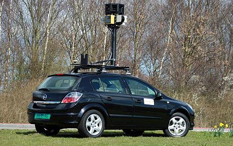
A Google Street View Car - the ultimate GPS device!

01 February 2011

A Look Back: Urban Planning in America

The United States has a long history of Urban Planning, and an equally lengthy history of planning controversies. Americans generally approve of small scale local community planning, but residents are wary of any overreaching or burdensome planning. Americans like their communities to be clean, liveable and attractive, but they are generally hesitant to take steps to achieve such a result.

Never the less, the United States has some prime examples of revolutionary urban master plans. The 1950s saw an explosion of this low-density, suburban tract housing being built in master-planned communities. Americans moved into the suburbs in droves, aided by the automobile and ever-expanding network or highways.

Examples of Master-Planned Communities

Radburn, New Jersey and Levittown, New York are models of early suburban sprawl. As master planned communities, both these towns offered the spacious lots, good schools, and affordable prices which Americans desired. They also, however, ingrained in the American psyche a reliance on the private car which as we're now seeing has unfortunate consequences. 

Levittown, New York

For example, Radburn introduced the residential 'super block.' This land use layout called for a grid of large roads spaced 1 KM or more apart. Each 'square' would contain lots of houses and parks, and would be accessed via extensive bike paths and some roads (with lots of cul-de-sacs). This effectively created a mini-suburb within each square of the road grid.

A residential 'superblock' with large perimeter roads, and bicycle paths and smaller roads within. 
Cities such as Radburn and Levitttown set the stage for the surburbinization of America. Some other more efficient, ecological planning ideals did not quite catch on


Rise and Fall of the Garden City
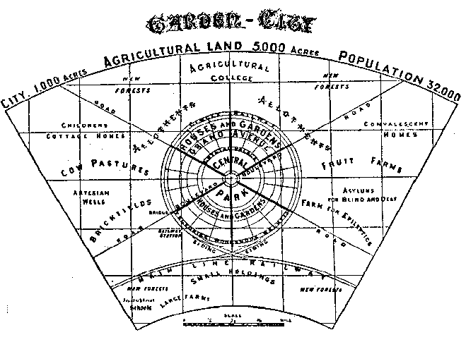
In the early 1900's, Ebenezer Howard designed a master layout known as the garden city. This regional planning strategy called for a series of dense, radial cities clustered around a major urban area, with efficient interconnections via municipal rail. This plan also emphasized the importance of green space in urban settings, and set aside large tracts of land in the city center for public use as open space.

The layout of Howard's "Garden City", with the main community in the center, and rail lines intersecting it diagonally to other communities. Unfortunately, modern planners often replaced rail lines with freeways when implementing this technique.

Garden Cities had some key advantages over "Levittown" style developments, They encourage a healthy lifestyle as they are designed for foot and bicycle traffic over automobile traffic. Communities are designed to be walkable, and house are set so porches face one another, encourage interaction among neighbors. Essentially, a city inspired by the 'garden city' design is a very nice, safe, healthy place to live.

One segment of a 'garden city.' Depicted are the wide avenues, parks, and hierarchical
arrangement of housing and commercial arrangement. 


The Bottom Line
America is a nation of large lots, single family homes and suburbs connected via freeway. Most of our urban planning takes after the 'Levittown' approach as opposed to building luxurious, aesthetically pleasing 'garden city' communities. 

Google Earth imagry of Levittown, NY Urban Sprawl

Concise, organized layout of Letchworth, England, which was based on the "garden city" design.

31 January 2011

My First Geocacheing Adventure - More Mesa

Yesterday began my foray into the wild world of geocacheing! For those of you who haven't heard of it, geocacheing is a hobby where one places a small container in a well-hidden public place, marks the location w/ one's GPS, and posts it online for others to find. Typical 'caches' include a logbook to register one's visit, and a variety of small trinkets meant to be traded by cache visitors. You should sign the logbook, and feel free to take and leave trinkets for others to find. It's like a long-term world-wide treasure hunt!

For my geocache, I went out to More Mesa in Santa Barbara. This Mesa is a large section of coastal open space, and has breathtaking views of the oceans and mountains. I found the caches I would look for on geocaching.com. I would highly recommended making an account there; it's free, and allows you to access all sorts of info on the various caches. You can see who has been there, and what comments they've posted about the condition of the cache, etc.

Our Route on More Mesa (looking N-NW)
We started at the sourthern end of Patterson Road in Goleta, and walked down to the trailhead for More Mesa. We spent a delightful afternoon of sun and rain criss-crossing the mesa, trying to find all the geocaches we had marked out ahead of time.

I have a Garmin Oregon 450t, and I was able to load geocache information directly from geocacheing.com to my handheld device! Very cool!

Our Blue Tracks in the greater Santa Barbara region


The Caches we set out to find!

Parking info!


Results: We found green pins, couldn't find red pins, and yellow are general information.
Caches generally contained a variety of small items in a waterproof container. Most are hidden within feet of major trails, but are hidden so as to be invisible unless you know where to look.

Over, this was a very fun experiment! Next time I would like to bring my trinkets to leave in caches, and also I will bring a camera and a notebook. I need to take more comprehensive notes on cache condition and contents to post it here. Also, I learned a lot about how to property use my GPS device for geocaching. It has a lot to offer, but is very complicated!

Files to download

29 January 2011

Visit San Francisco virtually! Bay Area now in 3D on Google Earth

On Thursday, Jan 27th, Google rolled out tons of new 3D features across the bay area in Google Earth. Some of the improvements include buildings, topography, famous landmarks, geographic features, etc! This is a cool way to get to visit the bay area without having actually been there.


Check out this cool 3D flyover from Google:


The GooglePlex in Mountain View, CA


Looking North over Hwy 1 at the Golden Gate Bridge and Marin County


UC Berkeley Campus


To make this work, be sure to install the Google Maps Plugin for Google Earth.
For More info, Check out the Google Earth Blog.


28 January 2011

You Plan SB: A Shining Example of Urban Planning

Today in my Urban Planning class at UCSB, we heard a lecture from Mr. John Ledbetter regarding the master growth plan for Santa Barbara. For the past fifteen years, Ledbetter has worked for You Plan Santa Barbara, an organization works with the community to develop and implement the SB General Plan.

The Santa Barbara Waterfront and Sterns Wharf

Mission Santa Barbara

Over the past twenty years, You Plan SB has worked with all residents to maintain Santa Barbara's charm, earning the city the moniker "American Riviera" and keeping it a desirable place to live, work, and play. The General Plan has limited commercial and residential sprawl considerably over the past twenty years by encouraging redevelopment of the central business district to achieve dense, mixed commercial and residential use. Dense growth is facilitated by the efficient street layout; despite being old and narrow, Santa Barbara's streets form a grid pattern which greatly eases traffic flow. It also makes an ideal environment for walking and  public transit. 

Downtown Santa Barbara


Geographic Information Systems (GIS) are essential to any type of urban planning. You Plan Santa Barbara has a wide variety of data available via maps, including land type, zoning, flood and fire risk areas, utilities, and public transit.

GIS map of level of urban noise in downtown Santa Barbara

Watersheds and drainage: important to understand potential
landslides in mountainous areas and flooding near the coast.
Want to learn more or get involved? You Plan SB has a great website for the public to learn about the project and to find out how to submit their comments, as residents' feedback has been essential for this whole project. Also available are all sorts of maps (like those pictured above) and documents which outline the plan in great detail.