28 February 2011

Genetically Modified Crops Flourish Globally - Dawn of a new imperialism?

Genetically Modified Crops are more widespread than ever and here to stay, according to a recent report from the International Service for the Acquision of Agri-Biotech Applications, a bioengineering trade group. 1 billion hectares of Genetically modified organisms were planted in 2010, marking a stunning adopting of GM crops since their introduction in 1995. 

Hectares of GMOs by country

Clive James, ISAAA's director and founder, told the BBC that more than 15 million farmers grow GM crops, and that, "during 2010, the accumulated commercial biotech plantation exceeded one billion hectares [2.47 billion acres]— that's an area larger than the U.S. or China," and equivalent to 10 percent of the world's arable land.


Its troubling to see that developing nations are planting GMOs at more rapid rate than developed nations. Multinational Corporations such as Monsanto profit tremendously off the adoption of patented GMOs, which are typically designed not to produce seeds which the farmer can reuse. This forces farmers in poor nations into a desperate cycle of mortgaging the farm to buy seeds from Monsanto. Often, Farmers who choose not to switch to GMO seed are forced to when their fields become pollinated from adjacent fields of GMOs. Once GMOs are in natural they cannot be contained, so hopefully they will not cause unforeseen consequences of a tragic nature. Regardless, its an excellent way for corperate hands to reach into the pockets of subsistence farmers around the globe by taking away what nature intended to be free: seed.


While we don't know if GMO crops are safe, it does appear that they are here to stay. Three helpless cheers for progress!

26 February 2011

Pacific Beach: Classic San Diego!

San Diego is a great city, and one of my favorite neighborhoods is Pacific Beach. Sandwiched between La Jolla, Mission Bay, and the I-5, PB is a neighborhood of apartments and bungalows teeming with 20-somethings and families.


Garnet Street is the main business district of the area, and is lined with cute shops and restaurants to explore. The streets are arranged in a grid fashion, and many have views of Mission Bay to the south and the ocean. Garnet ends at the beach in Crystal Pier, a combination pier/hotel which features over-water cottages for rent. Its beautiful to walk out, and you can feel the pier rock beneath you during heavy surf.

Crystal Pier hotel with PB and Mission Bay in the background.
Pacific Beach has a long boardwalk along it which is great for walking, jogging or biking. Many beautiful houses line the waterfront, giving the whole area a festive, lively attitude. It can be nice to work up a sweat jogging along the beach and than jump into the cool surf to cool off. Just make sure to watch out for stingrays! They can be quite common and do sting if stepped on. Locals recommendatory doing the 'stringray shuffle,' which involves dragging one's feet on the underwater sand to alert the stingray and give it time to get out of your way!

Pacific Beach Boardwalk!

24 February 2011

Will 4G break your GPS?

All four major US cell carriers are beginning to roll out '4G' service via LTE or Wimax, and engineers are worried that GPS coverage will be disrupted over large portions of the country. Apparently, 4G and GPS satellites use similar areas of the spectrum, and when the two types of units get close, 4G signals win.

Guess we can always get a ...shudder... map

Physorg.com recently cited two Garmin engineers who tested for interference between 4G transmitters and GPS receivers. They found that:
"The [handheld] GPS began to experience interference when 5.8 km or closer to the simulated transmitter and lost the fix altogether when 1.1 km away. Interference started at 22.1 km for the aviation receiver, and total loss of fix occurred at 9.0 km from the transmitter." 
The U.S. Air Force has also expressed concern over likely GPS disruption, but is optimistic about working with 4G infrastructure provider LightSquared to remedy the issue.

GPS deadzones might prove a bigger problem for planes, which
rely on GPS to determine speed. And to navigate through
clouds and across oceans! Not to mention ships...

Lightsquared Spokesperson Jeff Carlisle said that the 4G base stations are not at fault. Instead, he explained that some GPS units can 'see into' adjacent frequencies, including the one which Lightsquared uses.

22 February 2011

Navigate Santa Barbara's bus system using Google maps!

Google Transit has been steadily expanding to include 448 cities around the world. Transit is part of Google Maps, and it plans trips based on public transit's schedule, route, cost, and will even estimate walking distances to and from each stop. It makes a great way to plan a transit trip in an unfamiliar city, or compare the travel times or taking the bus versus driving or biking.


Santa Barbara's MTD was recently added to Google Transit, and I have been using it every day to plan my trips to and from school. Now only if there was an android app for SBMTD's schedule.


Google Transit in action!

Wet Concrete - A rainy day drive through Southern California

Southern California is an urban jungle. This connurbation is among the largest in the United States, and extends from Santa Barbara County to Tijuana, Mexico and east to Riverside Country and the deserts of the Southwest. Tall downtown areas are surrounded by unrelenting low density sprawl, and jammed freeways criss-cross the arid landscape. 

Last weekend, I drove from Santa Barbara to Pacific Beach, San Diego for a visit. The drive should have taken four hours, but traffic and weather combined to tack an additional two and one half hours of delay. Additionally, about 40% more gas was consumed that would be expected for the mileage of this trip. This makes sense considering long stretches of the drive were in first or second gear!

Route
 We left Santa Barbara on HWY 101 southbound and followed this through Ventura Country and up and over EL Camino Peak into the San Fernando Valley. SFV, as it is known locally, is a conglomeration of suburbs bordered on three sides by mountains which seeks to differentiate itself from LA by offering residents a higher quality of life than locations closer to the city.


US 101 at El Camino Peak


San Fernando Valley looking E-SE towards Hollywood Hills and LA

Here I caught I-405 S through the Hollywood Hills
 In the SFV, I got on interstate 405 heading south towards San Diego, and was immediately stuck back in traffic. For the next 100 km. In in the hardest rain I have ever experienced in southern California. We passed accident after accident, as 12 lanes (each way) of traffic squeezed through this notoriously busy section of freeway.

HWY 73 - Public vs. Private?
 On the southern end of the LA area, traffic was still brutal so I chose to take a toll road for part of the journey. Hwy 73 is privately owned and operated, and provides a traffic free, well maintained shortcut across Laguna Nigel and around urban Irvine, CA. In the picture above, you can see the 3 main N-S corridors: I-5 (left), I-405 (middle) and Hwy 73 (right). The two interstates go through flat, congested areas and are always clogged with traffic and heavily rutted with potholes. Hwy 73 is meticulously paved, and traffic is light as the highway climbs through much nicer, more exclusive neighborhoods. The trip on the toll road cost me US$4 which I paid via Fastrak transponder, but I do believe the price varies with congestion level.

South of LA on I-5, Passing the San Onofre Nuclear Generating Station

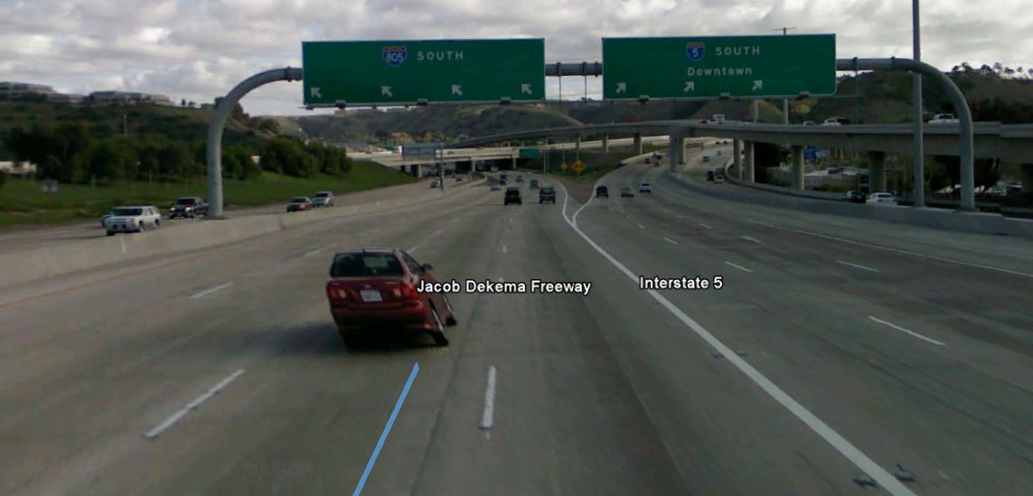
One nearing San Diego, I was getting tired and not paying close enough attention to the signs, and I accidental ended up on I-805 instead of I-5. The 805 was now taking me on an inland detour and was in fact heading away from my destination! Darn!

Oops! Ended up on 805, grabbed the 52 back to the five!

ZZZzzzzzzzz..... missed this sign.
 Luckily, in Southern California every freeway connects with every other freeway multiple times, so I had no trouble finding a new route to my destination. All I had to do was take 52 E to I-5 S and I was there. If I had missed the 52, I would have had several other alternate freeway routes within the next several miles. This sheer complexity of this freeway systems leaves me in awe every time I pass through.


Finally! Got of the 5 and headed west into Pacific Beach!
Come back next time for more info about the darling beach neighborhood of Pacific Beach! It's Southern California at its finest!

Elevation and Speed Profile - Spent a lot of time in traffic on this trip!
Download the KML file

20 February 2011

National Broadband Map

The National Broadband Map, launched yesterday, “is a searchable and interactive website that allows users to view broadband availability across every neighborhood in the United States.” Not surprisingly, the $200-million project, with 25 million searchable records, shows a clear divide between urban and rural connectivity. More at Engadget, Flowing Data and the New York Times

Thanks to http://www.maproomblog.com/ for the lead!

15 February 2011

Stuck in GIS file format hell?

Geographers use a wide variety of devices which record information in many different ways. For example, my GPS Unit records track data and waypoints in the GPX file format. Google Earth can import GPX files, but saves data as a KML file.

File conversions can leave you cross-eyed!

This creates a problem in my geoloation workflow: if I create a route in google Earth, I cannot save it onto my GPS handheld for later use because the KML file format is not compatible. Luckily, a variety of free file convertors are available for converting to and from all sorts of GIS file formats.

I have been using GPS Babel to convert KML files to GPX files. Its free, and has an easy to use web interface! You can also download the original command line version for use in the field without an internet connection, but, its more complicated UI has a steep learning curve.

GPX files are pretty cool! When opened in a text editor, it will open as a list of dates, times, and lat/long data. Basically, a text trail of bread crumbs to reconstruct your track. I have tried editing these files by hand (to remove part of the track, for example) and have had very limited success.

GPX file as viewed in text editor. Not Particularly useful.