10 March 2013

Turkey Launches Satellite to Capture Earth Imagery

On 18 Dec 2012, Turkey successfully achieved orbit of their new earth observation satellite, Göktürk-2. According to an article on NASASpaceflight.com, the satellite was launched from the Jiuquan Launch Area 4 in China, and successfully achieved low earth orbit within hours.

Göktürk-2 launching aboard a two-stage Chinese rocket.

Göktürk-2 will capture both panchromatic (black and white) imagery with a resolution of 2.5 meters, and multi-spectral (color) imagery with a resolution of 10 meters. Multi-spectral imaging captures different wavelengths of light separately, allowing researchers to compare and analyze different types of light to gain detailed information about conditions across the earth's surface.  For example, multi-spectral satellites can map vegetation health by comparing how much visible light plants reflect with the amount of reflected  infrared light. Stressed vegetation reflects more visible light and absorbs more infrared light than healthy vegetation, allowing researchers to use imagery to identify areas where ailing plant health may hurt food production, or to identify the impacts of global climate change on sensitive habitats.

All of the software running on Göktürk-2 as well as 80% of the satellite's hardware was designed by the Scientific and Technological Research Council of Turkey (TÜBITAK), and assembly was completed by the TÜBITAK Space Technologies Research Institute (TÜBITAK UZAY) and Turkish Aerospace Industries (TUSAŞ). The satellite showcases Turkey's rising status as a technological powerhouse, and will prove to be a major strategic advantage by providing Turkey's Defense Department with remote imagery from countries around the globe.

Göktürk-2 in the lab before leaving earth.


Many countries already have satellites orbiting the globe for a variety of purposes, such as imagery collection, communications, and navigation. Over 200 publicly and privately owned satellites have been launched from the United States alone. Turkey no longer must rely solely on data provided by the international community to map and research important environmental phenomena, and can now produce such data first hand. Göktürk-2 is part of a family of satellites planned by Turkey to further facilitate data collection and augment existing intelligence resources.

21 February 2013

Bill of Rights Does Not Apply to 66% of Americans

In their ongoing mission to defeat the terrorists, the Department of Homeland Security (DHS) has suspended the constitutional rights of 200 million Americans with a move that makes Senator Joseph McCarthy seem well reasoned and logical.


The Fourth Amendment of the Bill of Rights gives Americans protection against unreasonable search and seizure of their person and property. Just to review, here is the text of the fourth amendment as posted on the U.S. Government's document archive site (source).
Amendment IV
The right of the people to be secure in their persons, houses, papers, and effects, against unreasonable searches and seizures, shall not be violated, and no Warrants shall issue, but upon probable cause, supported by Oath or affirmation, and particularly describing the place to be searched, and the persons or things to be seized.

The DHS has claimed a long-standing right to search people crossing our international borders. Upon superficial consideration, this seems reasonable. But consider the smart phone, tablet, or laptop. These devices contain a person's most personal and sensitive data. If the data isn't stored on the device itself, than the device most likely will provide agents access to data stored online.

The DHS claims that these devices can be searched as part of a border crossing inspection. However, these devices contain access to an individual's most intimate and private data. By obtaining someone's device, one gains access to their email, phone records, bank accounts, photos, documents, and other private data. Therefore, searching one's laptop, tablet, or smartphone is not the same as searching their pockets and briefcase. In fact, searching an electronic device is more analogous to searching their entire home, office, and car all at once. By looking through a device, border agents can review and seize any and all of that person's private information.

An easy solution would be to only carry "dummy" devices when traveling internationally. For example, I can take a laptop with no personal data on it, and access my data online when I arrive at my destination. I can also encrypt my data, so if my computer is seized at the border, agents will only be able to see a scramble of nonsensical 1s and 0s.

Unfortuately, border searches are NOT limited to the border. The DHS claims that the internal border extends 100 miles inland, and therefore anyone within 100 miles of the border can be searched without probably cause and without a warrant. .66% of our nation's population (over 200 million people) lives within 100 miles of the border, and are therefore subject to search and seizure of their electronic devices and data at any time and place without a warrant.

Here is the ACLU's map of what it calls the "Constitution Free Zone". 
2 out of 3 Americans live in this Constitution Free Zone.
© American Civil Liberties Union

Do you live in it? Most of us do. 99% of Californians do, as do 88% of Arizonians. If you live in Connecticut, Delaware, Florida, Hawaii, Maine, Massachusetts, Michigan, New Hampshire, New Jersey or Rhode Island, then your entire state is a DHS search and seizure zone. So, you know, good luck with that.

 Therefore, most of us no longer have the right to avoid unreasonable search and seizure. So if and when you see those flashing reds and blues in your rear view mirror, and you're in the orange section on the map above, you'd best start deleting your hard drive and smart phone memory. Unless, of course, you are ok with the government having access to your entire digital life including your banking info, email, web browsing history, and location data. I, for one, do not consent to waive my 4th amendment rights. I have nothing to hide, but as the founding fathers intended, the U.S. Government cannot require me to prove that.

Thanks to Darlene Storm, whose ComputerWorld article on this topic inspired mine. Read her article here.

08 August 2012

Why Can't (the carriers) Just Get Along?

No matter how hard they try, it seems that large companies have a tough time working together; as a company grows and its bureaucratic develops, the company seems less and less able to deliver products in a responsive manner.

Case in point: the wireless carriers. Sprint, Verizon, At&t and T-mobile all have network-based location capabilities, but none are available to app developers via a simple-to-use API. With this API, developers find it extremely difficult to utilize network-based location on their apps. The Wholesale Application Community (WAC) was a cross-carrier partnership who's goal was to allow any app to be used on any handset on any carrier. Under this Utopian coalition, a developer would build their app to WAC standards, and then would be able to deploy the app across carriers. It turns out that the carriers each had their own idea of how this should work, and after years of infighting, the WAC dissolved with few results for years of effort.


So what's a cross-carrier app developer to do? Well, if the end goal is to inoperative carrier-grade network location services, then companies like LOC-Aid are the answer.The carriers specialize in building infrastructure that operates with 'five 9s' reliability, and therefore innovation on the carrier side is a slow, painful process. LOC-Aid (for who I do contract work, full disclosure) specializes making carrier location services available through a modern, well-built API that app developers find easy to use. The carriers handle the back haul equipment and reliability, and LOC-Aid provides an innovative, high tech front which developers can use to bring the latest location technologies to their apps without direct carrier interaction.

The failure of the WAC shows how intermediary companies such as LOC-Aid continue to provide a highly valuable service to developers and end users. Maybe some day that telcos will learn to play nicely together (not likely), and until then, let someone like LOC-Aid handle the tough carrier negotiations!


04 August 2012

Just How Big is Los Angeles?

Los Angeles is the urban sprawl capital of California. Simply climb to the top of any of the many mountain ranges which surround the city; one can see freeways, blocks of buildings, and endless ballet of cars, usually through a thick blanket of smog. 

Los Angeles Skyline and San Gabriel Mountains
Image © Charles Abbott, 99 Photography

Ask anyone who lives in the area: no on gives a second thought to driving 45 minutes at the top of the hat, or assuming that traffic will delay one's arrival for at least another 30 minutes. These constant traffic snarls and delays are simply a part of life for the average resident of the area.

The Hollywood Sign
Attribution: User Oreos at Wikimedia Commons

So why is traffic also so bad? How did Los Angeles earn the reputation as one of the most trafficked city in the country? Well, take a look at the map below and see how much larger of a geographic area the city covers when compared with other cities. A resident of LA simply has a much larger area which they will be expected to transverse for work, school, or pleasure. And because everything is so spread out, many areas are impractical for mass transit, keeping everyone stuck in their cars.

Size of Los Angeles vs. other urban centers
Attribution: Archinect News


27 July 2012

Exploring Sonoma Valley Wine Country - On a Segway!


When it comes to wine tasting, I am traditional. I like to spend time taking in the rich aromas, colors, and tastes of each wine. I chat with the workers at the vineyard to get a sense of the love and care put into production. When possible, I always like to see the grapes themselves out in the field. (Not that I know much about wine tasting, but I try and copy what I see other 'wine snobs' doing!) 

Thankfully, my traditional tastes only apply in the tasting room and not to the method of transport used to get there, because I arrived to each vineyard on the back of a wild electronic steed, more commonly known as a Segway!

My dad had some about-to-expire coupons he'd bought on groupon for this wine tour by a local firm called Segway of Healdsburg, so he insisted I use them. "Ok, If you insist," was my reply. The tour started off in a park and ride parking lot in Healdsburg, right off HWY 101. The Segways come to you in a van, charged up and ready to go. They guides teach you how to ride in the safety of the big empty parking lot, which was great because I had never been on a Segway before, but thankfully it was super easy. We took a quick trip up a side street to make sure our Segwaying skills were up to snuff, and then we were off!

Location of the tour's starting point in relation to the bay.

Overview of our route.

My tracks when I was practicing back
and forth in the parking lot!

And the side road we practiced on.

After getting the hand of it, we headed down a main road to Limerick Lane, a quaint country road dotted with small vineyards. Segways are legally bicycles, so we stuck to the bike lane, but boy did we get some funny stares from passing motorists!

Aerial View of Viszlay Vineyards. 
Our first stop was Viszlay Vineyards. John, the owner, conducted our tasting himself around a shady outdoor table adjacent to the fields of vines. John told us he is a recent transplant from Chicago who decided to try his hand at wine making, and boy, he is doing something right! I am not a fan of Chardonnay, but we tasted a Chardonnay so crisp and delicious that I had to purchase a bottle. It felt great to buy something in cash directly from the person who had made it - this is how agriculture should work! And of course, we got him to sign the bottle.


Aerial View of Limerick Lane Cellars, with its bottle-shaped pool!

Our second and final stop was just down the road to a place called Limerick Lane Cellars. The tasting room here was much more formal, with dark woods and ornate decorations. The tasting assistant was very helpful and knowledgeable, and he gained my respect with his honesty; his personal favorite on their tasting list was also the cheapest, so he didn't seem to be trying to upsell us. 

Limerick Lane Cellars has been around for a while; some of their vines have been producing grapes since 1910! These old vines are unique because they were keep alive during prohibition when most grape vines in the area were ripped out. Due to their age, their roots reach down to the groudwater, meaning that these vines are non-irrigated. The reliance on groundwater gives the fruit a special kind of taste which you would not get with irrigated vines! We ended up buying a bottle of Zin from vines planted in the 1930's, and I cannot wait for a special occasion to drink it.

Overall, the Segway tour was a blast! I'd highly recommend taking the tour with Segway of Healdsburg, but even if you go it alone to Sonoma Wine Country, be sure to stop by Viszlay and Limerick Lane Cellars! Click here for photos of the trip taken by our tour guide!


Here is an interactive map of our route: The pins show the starting place and the location of both vineyards. Click on them for more info!


View Larger Map

25 July 2012

Megaregions: New Ways of Thinking About the Modern United States


It appears that States, Counties, and Cities are having a smaller and smaller influence on the development of the United States. People today commute father to work than ever before, and in most central cities hold much less relevance than they once did. Suburbs and Exurbs have spread the population across huge areas such that it is often difficult to distinguish where one city or region ends and another begins. 

Historically, the central business district of a city demanded the highest rent and therefore was home to highly productive economic activities (technology, manufacturing) and small, expensive housing units (apartments). As distance from the city center increases, housing costs typically decrease and economic activity becomes less dense and lower profit.

Housing Availability vs. Distance from city center.
Attribution: The Tyson's Corner

Once the industrial revolution and the automobile made commuting either, both residents and business fled the city for cheaper rents out in the country. The megaregion is the natural extension of this trend: proximity to a major city center is having less and less affect on locations selected for homes and businesses, and workers are increasingly expected to commute long distances or work remotely.

Instead of defining areas by city or county, it may be more accurate to group areas into larger, inter-state 'regions.' Recent research by the America 2050 initiative has concluded that eleven so-called 'megaregions' are poised to become the default unit for grouping people and places. 

According to Wikipedia: 

A megaregion is a large network of metropolitan regions that share several or all of the following:
Environmental systems and topography
Infrastructure systems
Economic linkages
Settlement and land use patterns
Culture and history

Essentially, a megaregion is anywhere with strong ties to surrounding areas. Megaregions are seperated by areas of low population density and less progressive economic activities. The map below really shows that the vast majority of land area in the United States has little to no population. Shaded megaregions account for 26% of land area in the U.S., but over 74% of the population!

Megaregions of the United States
Attribution: Maps of America 2050*

Viewing Megaregions as cohesive units can allow for more effective urban planning, as it allows entire urban ecosystems to be taken into account at once. In the day and age of megaregions, planning for a single city or country simply does not make sense anymore, as good urban planning requires every aspect of the urban ecosystem to be evaluated and accounted for.


 *Map Attribution:
Creative Commons License
Maps by America 2050, Regional Plan Association are licensed under a Creative Commons Attribution-Noncommercial 3.0 United States License.
Based on a work at www.america2050.org. 


23 July 2012

Peaks and Valleys - Exploring the Geology of the South Coast

I am taking UCSB's Intro to Geology class this summer, and we just went on our field trip to observe geological formations in the Santa Ynez mountains. The trip really helped me understand the formation of rocks, mountains, and valleys; geology is a lot easier to understand when observing it in the field than learning about it in the classroom.

Our class piled into vans and went up Gibraltar Road, which begins in the foothills of Monticeto and winds its way up to the ridge of the mountains. Along the way we stopped several times to observe different layers of rock where they protruded from within the mountains. The Santa Ynez mountains are composed primarily of sandstone and shale. The sandstone is relatively hard and tends to form peaks, while the shale is softer and erodes more easily.

An overview of our route.

Route overview, including return trip.

Speed/Elevation Profile: Speed is purple, and elevation is in red.

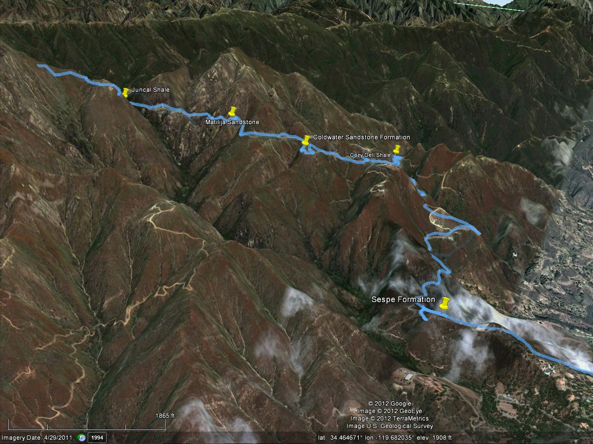
The main formations we viewed, in the order we passed them, were:
  • The Sespe Sandstone Formation - a reddish sandstone with lots of rocks and pebbles mixed in.
  • The Cozy Dell Shale Formation - very soft shale which would crumble in one's hand.
  • Coldwater Sandstone Formation - hard, durable rock which comprises the peaks of the Santa Ynez Mountain Range
  • Matilija Sandstone - like the coldwater sandstone, but with more shale mixed in.
  • Juncal Shale - Another bed of soft, crumbly shale.
 The rock layers formed due to rising and falling ocean levels. High ocean levels deposit fine silt, which becomes shale. When the ocean was lower, layers of sand would be deposited over the silt, forming sandstone. The layers of rock were flat until about 1.5 million years ago, when movement along the San Andres fault squished the rocks and bunched them up into mountains. Its crazy to think that rock in these ~4,000 foot high peaks formed under water originally.

A view of our route looking north.

A good outcropping of the bottom layers of Sespe formation
was visible here.
At our first stop we viewed the Sespe sandstone formation, along with some 'fanglomerate' which is comprised of sandstone which had erroded from the peaks and ended up at the bottom of a valley. The ridges surrounding this valley have since eroded away, leaving the fanglomerate perched up on a ridge.


Cozy Dell Shale near the 'No Shooting' signs on Gibraltar road.

The sandstone formations are much harder and therefore form the peaks of the mountains. Areas comprised of shale are soft and erode into valleys. These alternating bands of shale and sandstone help explain the formation of the moutain's topography.

View from the Coldwater Sandstone pin, looking west.

We stopped to view the coldwater sandstone formation from a distance. The above image is the view we saw; notice how there are two peaks with a valley inbetween. The peaks are both comprised of sandstone while the valley is mostly shale.

Again, notice how the sandstone is perched on a ridge, while the shale
is visible in the valley.
 We ended out trip at La Cumbre peak, the highest peak in the mountains, where we had a terrific overview of the terrain we had just driven through up close.

The view from La Crumbre Peak, looking East.
A good portion of our  route is visible.

Here is an interactive map of our route. If you zoom in, you can see areas where there appears to be lots of frantic running around. These areas are where we stopped and got out of the vans to walk around, and the GPS unit recorded my movements as I examined the rock formations!


View Larger Map